
Kola map by Orbx Systems
Early Access is now available
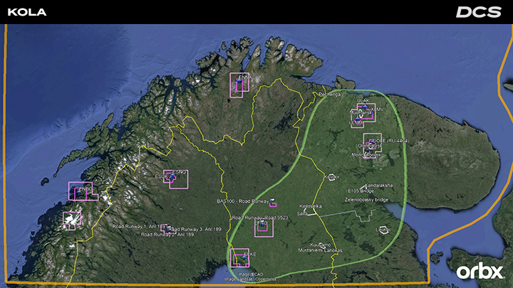
 Orbx is pleased to announce that its DCS: Kola map is now available in early access. The map covers northern Norway, Sweden, Finland, and the Russian Murmansk Oblast and parts of the Karelia region. It also includes large areas of the Barents Sea and Norwegian Sea to the north and west, ideal for aircraft carrier operations.
The DCS: Kola early access release is offered with a special 20% discount ($55.99 USD), for a limited time whilst the Orbx team work to expand the content, detail, number of air bases, cities, towns, villages and infrastructure. The map price may also increase accordingly, so make sure you secure your discounted version now.
The early-access release of DCS: Kola focuses on a large area that spans the Finland/Russia border and encompasses, central Finland and the western parts of the Murmansk and Karelia regions of Russia (see map). Within that subregion are several higher detailed areas, centered on airports in Finland (Rovaniemi, Kemi Tornio plus two road airbases), and Russia (Olenegorsk, Severomorsk 1, Severomorsk 3, Monchegorsk, and Murmansk International), and their urban and rural surroundings and infrastructure. Outside of this focus area, two airports in Norway (Bodo and Laksekv) and three in Sweden (Kalixfors, Kiruna, and Jokkmokk) are functional but not fully detailed yet.
Orbx is pleased to announce that its DCS: Kola map is now available in early access. The map covers northern Norway, Sweden, Finland, and the Russian Murmansk Oblast and parts of the Karelia region. It also includes large areas of the Barents Sea and Norwegian Sea to the north and west, ideal for aircraft carrier operations.
The DCS: Kola early access release is offered with a special 20% discount ($55.99 USD), for a limited time whilst the Orbx team work to expand the content, detail, number of air bases, cities, towns, villages and infrastructure. The map price may also increase accordingly, so make sure you secure your discounted version now.
The early-access release of DCS: Kola focuses on a large area that spans the Finland/Russia border and encompasses, central Finland and the western parts of the Murmansk and Karelia regions of Russia (see map). Within that subregion are several higher detailed areas, centered on airports in Finland (Rovaniemi, Kemi Tornio plus two road airbases), and Russia (Olenegorsk, Severomorsk 1, Severomorsk 3, Monchegorsk, and Murmansk International), and their urban and rural surroundings and infrastructure. Outside of this focus area, two airports in Norway (Bodo and Laksekv) and three in Sweden (Kalixfors, Kiruna, and Jokkmokk) are functional but not fully detailed yet.
 [b]Key Features of the Early-Access Release[/b]
- Complete base terrain for the entire map area, with detailed topography, summer ground textures summer, shorelines, and lakes and rivers.
- An initial focus area spans the Finland/Russia border and encompasses central Finland and the western parts of the Murmansk and Karelia regions of Russia (see map).
- Four high-detail areas, focusing on two airports in Finland (EFRO, EFKE) and five in Russia (XLMV, ULAK, RU-1110, RU-4464, ULMM), and their urban and rural surroundings and infrastructure.
- Two road runways in Finland, near Rovaniemi and Sodankylä, respectively.
- Two additional airports in Norway (ENBO and ENNA) and two in Sweden (ESNQ, ESUK, and ESNG) are functional but not fully detailed at early-access release.
- Significant civilian POIs include bridges, vertical obstructions, monuments, hydro dams, power stations, port facilities, landmark buildings, open-pit mines, towns and small villages, and industrial sites.
- Improved night lighting for cities and towns.
- Main road and railroad network, with bridges and tunnels, which are connected across the map that allows long-distance AI routing.
- Natural landmarks and geographic features, such as Norwegian fjords, detailed coastlines, snowfields, forests and wetlands, tens of thousands of lakes, and large river systems.
- Map features represent the current era but includes allowances for the late-Cold War era – e.g., operational road runways and fully functioning Russian air bases – to enhance mission options.
- The Orbx team is collaborating with experienced DCS campaign creators Baltic Dragon and Reflected Simulations to create engaging campaigns.
- Complete set of winter textures that load dynamically based on mission date to accurately represent the cold and harsh climate of the Kola area.
- Additional detailed military airfields, including Andøya, Bardufoss, Kirkenes, Evenes, Vidsel, Kilpyavr, Alakkurti, and others.
- Additional military installations like naval and army bases, barracks, ports, storage areas, training areas/ranges, radar and communication sites, and air defense sites.
- Additional Cold War Era Swedish and Finnish road runways.
- Additional civilian airports, including Tromsø, Hammerfest, Ivalo, Luleå, and others.
- Additional detailed cities and towns, POIs, and industrial sites.
- Improvements to landscape features and detail, as well as additional areas with high-resolution aerial orthoimagery.
